Posts

The month of spring is beginning on a stormy note for Northern India

Image
  The weather has been very dry lately after a nearly winter drought due to the absence of winter rains in the region. There were weaker & less frequent active Western Disturbances which brought some rains but some of them traversed in lower latitudes as compared to their normal track. These lower latitude systems brought active spells over West, Central, and parts of Eastern India while sparing Northern India. The winter produce in the region has not been good! Now, the pattern is expected to get wet and stormy due to the active impulse of NAO coupled with favorable dynamics for the first half of the month of March. A very active Western Disturbance is set to end the dry spell with a bang across many parts of Northern India and it will bring the season’s first rainfall in many places that have been devoid of any rainfall for the past 2-3 months. Weather synopsis  •Western Disturbance: A Western Disturbance (WD) as an upper-level disturbance is present over North Pakistan and adj A
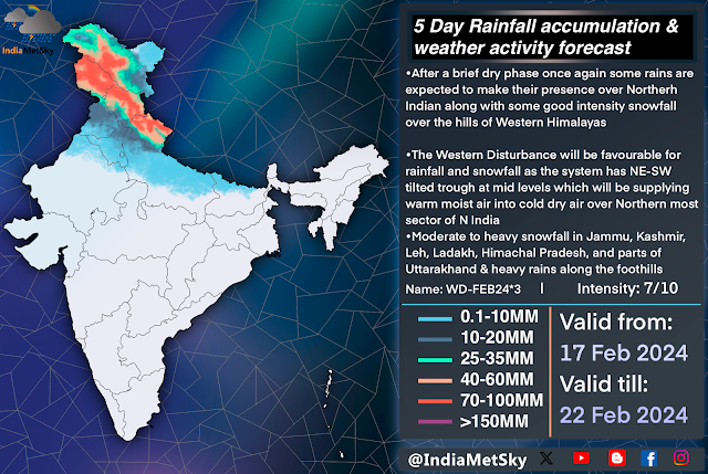
Fresh spell of some rains over Northern India to welcome the slow spring transition

Image
  The weather has been pretty dry with a slow but warm trend with occasional high level clouds and some isolated fog across the parts of North India like Punjab, Haryana, Delhi, UttarPradesh, Rajasthan, MadhyaPradesh while the few higher reaches of Jammu, Kashmir, Ladakh, Leh, Himachal has gotten isolated light snow on few occasions in past 10 days. The weather is about to take a turn as a slightly active Western Disturbance is on its way to affect Northern India between 17-22nd Feb. The spell has positive Arctic Oscillation, Elongated Mid level trail trough (negative tilt), Strong Moisture feed at mid level from Arabian Sea support. Weather Synopsis •Western Disturbance: A WD is present over the parts of N Punjab and Jammu Kashmir region and adj Pakistan region will be moving eastwards between 17-22nd Feb. The system has been graded 7/10 on the scale and is present between 250-500 hpa and will be spinning off a moderate intensity CC over N Rajasthan-SC Punjab region. •Cyclonic Circula

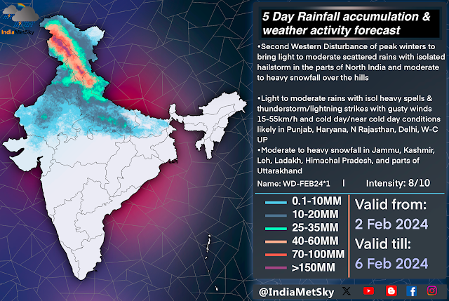
Fresh WD to bring more rains in the plains of North India and snow over the hills

Image
After a short break of a 2 days the rainfall is about to return back to the plains and hills of North India from this evening onwards as a strong active WD is approaching the region. This spell will bring good spread rains and hailstorms to the areas that might have missed the rains from the previous spell and more snowfall over the hills of Jammu and Kashmir, Leh, Ladakh, Himachal, Uttarakhand.  Weather features  WD: A strong WD of 8/10 magnitude at an height of 500hpa is expected to move over Northern India between afternoon of 3rd Feb into evening of 5th Feb  Induced CC: A induced Cyclonic Circulation is expected to form over North Rajasthan and SW Punjab which will pull the winds towards the North between 950-850hpa  Jet Stream: Relatively strong jet core is flowing over North India and it will aid the system  Moisture inflow: Moisture incursions from the Arabian sea  Weather effects  Spell is expected to bring good spread light-moderate rains with scattered heavy rains/hailstorm i

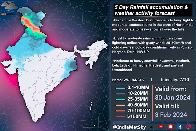
First Active Western Disturbance of peak winters to bring sct rains in the plains and heavy snowfall over the hills

Image
  North India is facing a large rainfall deficit due to the absence of active Western Disturbances while the Himalayas also faced a prolong dry spell which resulted in no snowfall over famous tourist spots and other neighbouring places of northern hills. There has been no rainfall activity in the plains of North India since November and a super long run of dry and foggy winter are maintaining their streak for more than a month. There has been some good news as a fresh active western disturbance with favourable conditions to bring scattered light to moderate rains in the plains and moderate to heavy snowfall at the hills Weather synopsis  •WD: Active Western Disturbance of magnitude 7/10 is approaching North India and would start to bring some activities from the night of 30th Jan •CC: A weak cyclonic circulation has been induced over Northern Rajasthan  •Weak Moisture flow from East (Bay of Bengal) and moderate moisture incursion from the Arabian Sea •Jet Stream: The jet is roaring at

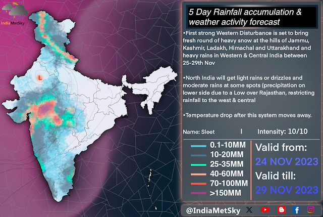
First intense Western Disturbance of the season brings wet weekend for West-Central & Northern India

Image
  The long wait for season’s first intense and active Western Disturbance is over as a active WD system is on its way to affect Northern India Including Western & Central India this weekend! The Subtropical Jetstream that dips snd creates Western Disturbances is dipping way over to the parts of SouthWestern India. This huge dip is created by huge pressure and temperature gradient over Mediterranean Sea and parts of adjoining Europe hence over stimulation and energising of the system by dipping of the Subtropical jet by the Jetstream.  This system has been rated at 10/10 on intensity and been named “WD-Sleet” by IndiaMetSky & CWDN council. Weather Synopsis  • Western Disturbance : Dipping of the Subtropical Jet at 200hpa and at 500hpa suggest a Western Disturbance with its trough extending upto the parts of SouthCentral and SouthWestern India between 25-29th Nov 2023. Winds at these levels are speeding between 120-150km/h and between 80-130km/h at 500hpa with a Southwards indent

Wet week ahead for Norther India and the IGP after scrutinising heatwaves

Image
The weather was pretty dry and unbearable hot across the many parts of India and spells of heatwaves brought the summer torment on every living being across the Northern India and the Indo Gangetic plains. East India on the hand were lucky as the region was getting back to back Nor’wester spells which cooled the region every other evening. The heat torment is about to end for a brief period as series of active back to back Western Disturbances are set to affect northern India and adjoining areas and the Indo Gangetic Plains. Lets dive deep into the synopsis and pattern! Weather Synopsis   •  Western Disturbance: A active western disturbance is expected to affect the parts of Northern India from the night of 23rd May. The system is rated 9/10 and has been named ‘WD-Nsar’  The system will be affecting the region between 23-28th May • Cyclonic Circulation: A strong CC or a low end Low Pressure Area to form over Pakistan and adj Northern Rajasthan. This system along with the WD will pull g

A long wet and pleasant spell for India is about to start from today

Image
  The long wait of a really good wet and cool spell is about to end after many disappointing spells and some traumatic ones. This spell will be fuel by variety of factors and it will be by far the wet and long spell of this Pre-monsoon season for Northern Plains, Western Himalayas, Central and Western India and many parts of East-South Indian region. Lets dive deeper and learn more about this hyped spell. Weather Synopsis • Western Disturbance: A strong WD will be affecting the Indian subcontinent from early 27th April and it will dip the Jet stream all the way upto South India. The system has been named WD-Sean and is coded as WD-APR7 and will be affecting the region between 27th April till 2nd May. There will be more systems on the way after that • Cyclonic Circulation: A induce CC to develop in the low atmosphere over North Rajasthan and surrounding areas. This will interact with the WD and pull moisture into the plains • Instability: The heat present in the plains from recent heat