Fresh spell of some rains over Northern India to welcome the slow spring transition
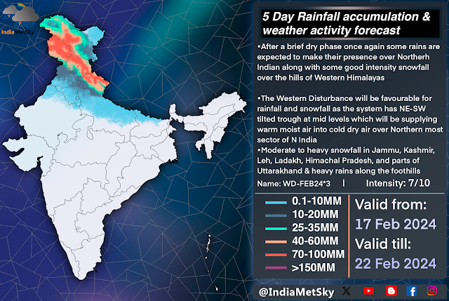
The weather has been pretty dry with a slow but warm trend with occasional high level clouds and some isolated fog across the parts of North India like Punjab, Haryana, Delhi, UttarPradesh, Rajasthan, MadhyaPradesh while the few higher reaches of Jammu, Kashmir, Ladakh, Leh, Himachal has gotten isolated light snow on few occasions in past 10 days. The weather is about to take a turn as a slightly active Western Disturbance is on its way to affect Northern India between 17-22nd Feb. The spell has positive Arctic Oscillation, Elongated Mid level trail trough (negative tilt), Strong Moisture feed at mid level from Arabian Sea support.
Weather Synopsis
•Western Disturbance: A WD is present over the parts of N Punjab and Jammu Kashmir region and adj Pakistan region will be moving eastwards between 17-22nd Feb. The system has been graded 7/10 on the scale and is present between 250-500 hpa and will be spinning off a moderate intensity CC over N Rajasthan-SC Punjab region.
•Cyclonic Circulation: A Induced Cyclonic Circulation (CC) is expected to form over N Rajasthan-SC Punjab region and it will pull and redirect the moist & warm winds from Arabian Sea into the North, especially along the foothills of Punjab, Tricity, Haryana, Chandigarh and parts of NW UttarPradesh. The system will move along the WD (Eastwards) before dissipating over the foothills of CE UttarPradesh.
•Moisture Feed: Moderate level of moisture pull from Arabian sea at middle and lower atmosphere whereas a convergence might develop converging along the two mass over Punjab, Haryana, Delhi and parts of W UttarPradesh which might aggregate few stray t-storms over these areas. The convergence will be radiating out from one axis of the CC
Weather Effects and Forecast
•17th Feb: The Outer bands from the WD will start to move over the plains and manifest themselves by developing a thin layer of high level clouds over the parts of Northern plains. The snowfall will begin in some higher and middle reaches of Jammu, Kashmir, Himachal Pradesh by late night snd would progress into other areas as well as acts will pick up pace on the intervening night of 17-18th.
•18th Feb: Snowfall activities will pick up pace over Jammu, Kashmir, Srinagar, Himachal Pradesh, Mandi and on/off rounds of snowfall will begin over the adjacent places like Mandi, Atal Tunnel, Kufri, Kullu, Manali, Kedarnath, parts of Uttarakhand. Few places might see blizzard like conditions, especially the higher and middle reaches. The high level cloud layer will thicken over Punjab, N Rajasthan, Haryana, Delhi, W UttarPradesh and adj places. Isolated light-moderate shower might make their appearance over Gurdaspur, Pathankot, Amritsar and adj N Punjab by the night
•19th Feb: (The peak of this spell will begin), The ongoing snowfall activities will cover all parts of the NW Himalayas by now and on/off varied intensity snowfall/hailstorms are expected to occur throughout the day while some isolated-scattered light-mod spells with isolated embedded heavy spells will occur between early morning into late evening in parts of N-NE Punjab, Foothills of Punjab & Haryana and few parts of plains of Haryana and parts of NW UttarPradesh. The probability increase as the progress into late afternoon hours. There is a fair chance for occurrence for moderate rains and isolated hailstorm over the parts of Punjab, Chandigarh, Ambala, Panchkula, Mohali, Kurukshetra and adj areas while places like Central Punjab, Haryana and Delhi will get overcast with isolated light-mod rains. These spells will pick up pace and spread and will be peaking between Aft of 19th Feb into Forenoon of 20th Feb.
-Delhi and Ncr have chances for ‘isolated’ light rains with few very isolated mod showers but conditions are not super favourable for any widespread spells.
•20th Feb: The spell will start to weaken up from the NW and will almost subside from the plains by evening but some isolated snowfall will continue over the hills with sct moderate snowfall likely over Himachal Pradesh and Uttarakhand. Few areas of UttarPradesh will start to get isolated showers by the evening of 20th Feb
•21st & 22nd Feb: No rain or snowfall is expected to occur in Northern India but few on/off varied intensity showers will occur in East UttarPradesh and Bihar, Chattisgarh, Jharkhand and parts of West Bengal.
High clarity nowcasts will be issued on our social media handles along with any changes in the forecast (if made)


Comments
Post a Comment