First intense Western Disturbance of the season brings wet weekend for West-Central & Northern India
The long wait for season’s first intense and active Western Disturbance is over as a active WD system is on its way to affect Northern India Including Western & Central India this weekend!
The Subtropical Jetstream that dips snd creates Western Disturbances is dipping way over to the parts of SouthWestern India. This huge dip is created by huge pressure and temperature gradient over Mediterranean Sea and parts of adjoining Europe hence over stimulation and energising of the system by dipping of the Subtropical jet by the Jetstream.
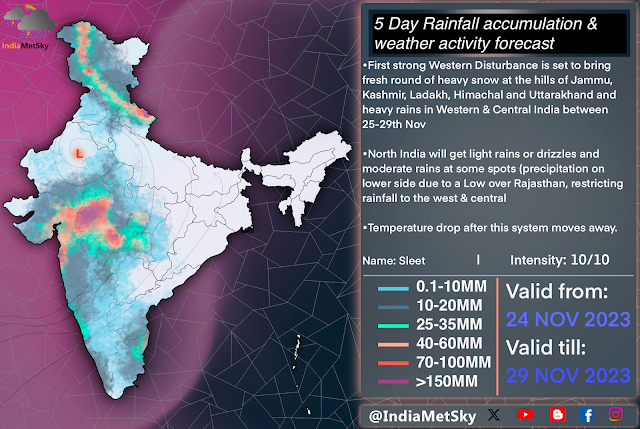
This system has been rated at 10/10 on intensity and been named “WD-Sleet” by IndiaMetSky & CWDN council.
Weather Synopsis
•Western Disturbance: Dipping of the Subtropical Jet at 200hpa and at 500hpa suggest a Western Disturbance with its trough extending upto the parts of SouthCentral and SouthWestern India between 25-29th Nov 2023. Winds at these levels are speeding between 120-150km/h and between 80-130km/h at 500hpa with a Southwards indent in the jet flow.
•Induced CC/LPA: A strong cyclonic circulation or a low intensity low pressure area is expected to develop over South-Central Rajasthan and adjoining MadhyaPradesh and NW Maharashtra due to the WD. This will be induced by the WD and pull the moisture from the Arabian Sea into the plains
•Dual Moisture Feed: The low pressure area and the trough of the WD will be pulling the moisture from the Arabian sea at higher levels while dumping huge quantities of moisture over the plains of Western, Central and parts of Northern India. The Low Pressure Area makes things favourable for active convection activity over these areas. Majority of the Moisture will be pulled from Bay of Bengal, therefore activities will be moving in from East to West (also reduced moisture content will reach Northern India and there won’t be much instability, so lower activities)
Weather Effects
Plains
Due to the effect of this system, we expect heavy widespread rains in Western and Central India but Northern states will get lower precipitation as most of the moisture and convective activity are expected to be in the South of the LPA.
Western India: Places like SW, South Rajasthan, Maharashtra, Western MadhyaPradesh will be getting the most impact as these places will be getting widespread moderate to heavy rains with strong winds at times and has higher risk of hailstorm on 26th and 27th Nov.
-Spell will start with onset of high clouds over these areas and onset of light rains and drizzles as the Saturday progresses. Activities will pick up pace by the morning of Sunday and peaking between Sunday afternoon into Monday night. We will also be having sporadic hailstorms, spells of intense rain and thunder. Also, Mumbai Rains will also be making their presence
-Activities will get reduce Tuesday afternoon and scattered t-storms will move east wards
North India: Such intense system and such low precipitation in the North when WDs are familiar with heavy rains during winter months. This is due to the formation of the Low Pressure Area with more southward development i.e over South-Central Rajasthan. This will restrict the rainfall towards the south of the system and the remaining of it will get orographic lifting by the Aravalli range and decaying clouds will move into other parts of Rajasthan, S Haryana hence the reduced rainfall.
-Few areas will get localised development and mostly light isolated-scattered rains with few moderate spells are expected in parts of Haryana, Northern Rajasthan, Delhi & Ncr, Western UttarPradesh between late of 26th into 28th Nov.
-Parts of Northern Punjab will get light to moderate rains from the t-storms which will affect the hills
Hills
•Many parts of Jammu, Kashmir, Ladakh, Leh, Himachal and Uttarakhand will are set to get scattered varied intensity rainfall at lower and mid levels and moderate to heavy snowfall at mid and higher ranges. Snowfall will be of varied intensity and will be at scattered levels.
Note-
This forecast is subject to change due to unknown changes in the atmosphere. There won’t be a significant changes but few things might change and they will be highlighted via our social media handle.


Comments
Post a Comment