Fresh WD to bring more rains in the plains of North India and snow over the hills
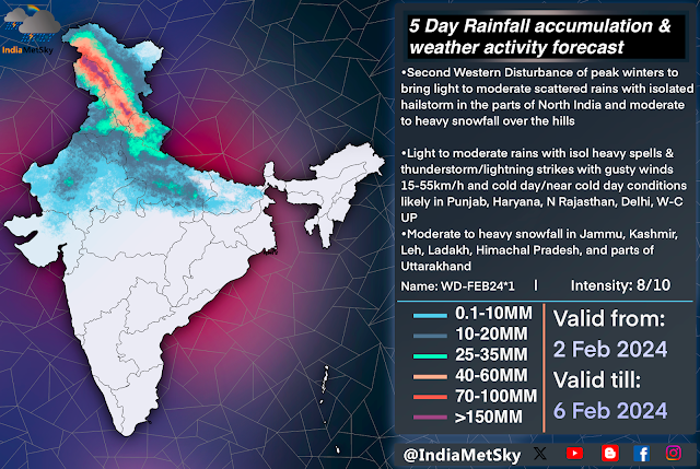
After a short break of a 2 days the rainfall is about to return back to the plains and hills of North India from this evening onwards as a strong active WD is approaching the region. This spell will bring good spread rains and hailstorms to the areas that might have missed the rains from the previous spell and more snowfall over the hills of Jammu and Kashmir, Leh, Ladakh, Himachal, Uttarakhand.
Weather features
WD: A strong WD of 8/10 magnitude at an height of 500hpa is expected to move over Northern India between afternoon of 3rd Feb into evening of 5th Feb
Induced CC: A induced Cyclonic Circulation is expected to form over North Rajasthan and SW Punjab which will pull the winds towards the North between 950-850hpa
Jet Stream: Relatively strong jet core is flowing over North India and it will aid the system
Moisture inflow: Moisture incursions from the Arabian sea
Weather effects
Spell is expected to bring good spread light-moderate rains with scattered heavy rains/hailstorm in Punjab, Rajasthan, Haryana, Delhi & Ncr, Chandigarh, Foothills and parts of NW-W UttarPradesh during late afternoon of 3rd Feb into late evening of 5th Feb. The hills will once again get moderate to heavy snowfall over almost all reaches of Jammu & Kashmir, Leh, Ladakh, Himachal Pradesh, Uttarakhand and adjoining areas.
Isolated light rains will begun by the late afternoon of 3rd Feb over the parts of North Rajasthan, Punjab, Haryana and the later would progress into other parts of these regions and Delhi and Ncr by the late night. The probability increase as the day changes into 4th Feb with activities picking up pace by early morning of 4th Feb, Many places in Punjab, Haryana, N Rajasthan and Delhi & Ncr will be receiving moderate rains with isolated heavy spells accompanied by gusty winds 15-45km/h and loud thunderstorms.
Some places might heavy rains and intense hailstorms due to high instability. Places like Sriganganagar, Hanumangarh, Bathinda, Malerkotla, Sangrur, Patiala, Chandigarh and adjacent areas have higher chances of heavy spell & hailstorm between 3 AM till 7 PM of 4th Feb.
Places like Eastern Punjab, East Haryana, NW UP will be getting showers till late evening of 5th Feb.
The peak of this spell will be in 4th Feb.
The hills will be getting on/off moderate to heavy snow and almost many parts of Jammu and Kashmir, Srinagar, Leh, Ladakh, Himachal Pradesh, Manali, Kullu, Kufri, Shimla, Uttarakhand, Kedarnath and nearby places during afternoon of 3rd into late night of 5th Feb


Comments
Post a Comment