Finally some good spread rainfall for the plains of North

The last WD system came as bluff for Northern plains as the system failed to deliver rains in Delhi, Haryana, and Parts of Punjab and Rajasthan while North Punjab, MadhyaPradesh, UttarPradesh and adj areas got fair amount of rainfall and some areas even got hailstorms while hills got good amount of snowfall and rainfall.
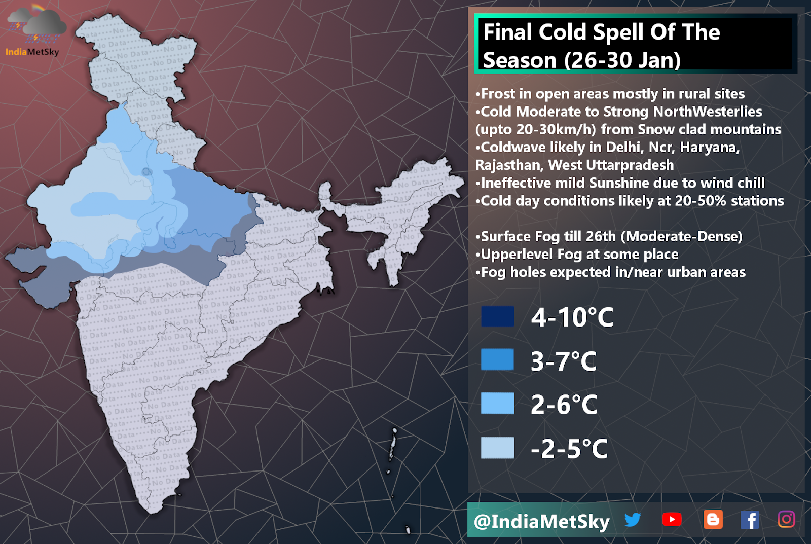
After a short and quick spell of cold wave the whole western Himalayas, Northern Plains and parts of central and western India are set to witness scattered thunderstorms, rains and hailstorms during next 3 days.
Synopsis
•Active WD (5) to affect the North Indian region between late 28th Jan into early 31st. The system is rated 9/10 and is named “Taru”
•Its Induced Cyclonic Circulation (CC) to form over adj central and north Rajasthan.
•Active moisture feed from both seas, Arabian Sea and Bay of Bengal. Good moisture flow from Arabian at higher levels too

Weather effect and forecast
Plains
•28th Jan: Nothing significant is expected apart from some showers by late afternoon or evening in the parts of Gujarat and adj 5-10% areas of Southern Rajasthan. Clear blue skies for all areas while foothills may observe fog during early hours. Tstorm and rainfall activities to start picking up by late evening in the parts f Gujarat and Southern Rajasthan
•29th Jan: The activities to start spreading and the Cyclonic Circulation has formed over Rajasthan. The clouding to increase too. Rainfall and isolated hailstorms are expected in parts of South-Central Rajasthan from early morning and these activities to intensify by afternoon and their effects to expand to other areas by late afternoon. Good chances for the Northern Rajasthan, Central Rajasthan while scattered light to moderate rains are expected in parts of Punjab, Delhi, Haryana and adj areas. Higher chances as the day progresses. Gusty winds upto 25-50km/h are expected too during the activities while 20-30km/h in the plains. Overall scattered activities covering 75-95% of the areas
•30th Jan: Scattered activities to spread to other areas of Haryana, Delhi, Western UttarPradesh, and parts of MadhyaPradesh overall same activities as 29th Jan but there will be decrease in western Rajasthan.
•31st Jan: activities to weaken and the belt will shift towards east, now UttarPradesh and adj areas to witness these acts with decreased intensity
Hills
•28th Jan: Light to moderate snowfall is expected to occur in pockets of Jammu, Kashmir and adj areas, mostly higher and middle reaches.
•29th Jan: Widespread moderate to mostly heavy snowfall at higher and middle reaches while light to moderate snowfall with heavy rains in lower reaches of Jammu, Kashmir, Ladakh, HimachalPradesh and parts of Uttarakhand
•30th Jan: Same as 29th Jan. More spread and intensity towards east
•31st Jan: Light to moderate snowfall and rainfall at many places and all the activities to decrease by night


Comments
Post a Comment