Southwest Monsoon 2022 outlook
Indian Summer Monsoon, the much awaited 4 month long season had arrived but with a weaker start. As there a saying 'Never judge a book by its cover' and we are expecting the same for SWM 2022
13 days into Monsoon, many places in southern India observed weakest onset in years and many stations are in large deficit apart from NorthEast India and parts of North, central & Northwest India are reeling under the grip of severe heatwave. Soon cards will flip as many parameters and atmospheric conditions are becoming favorable for further advancement of SWM and return of Pre-Monsoon rains in the North India. We will be talking about the pre-monsoon rain in our next blog and lets talk about SWM 22
ONSET CRITERIA
Dynamical parameters that are required for declaration of onset of SWM over Kerala are as follow
•Low value of Outgoing Longwave Radiation (OLR). OLR valves below 200 wm2 are perfect for declaration of monsoon onset
•Presence of westerlies wind depth from surface to 3.5 kms above surface
•Light to moderate rainfall for two consecutive days over atleast 60-80% of the area
•Strengthening of LLJ (Low Level Jet) or Somali jet, low level wind jet which aids in advancement and formation of sw monsoon
KEY POINTS ABOUT SW MONSOON 2022
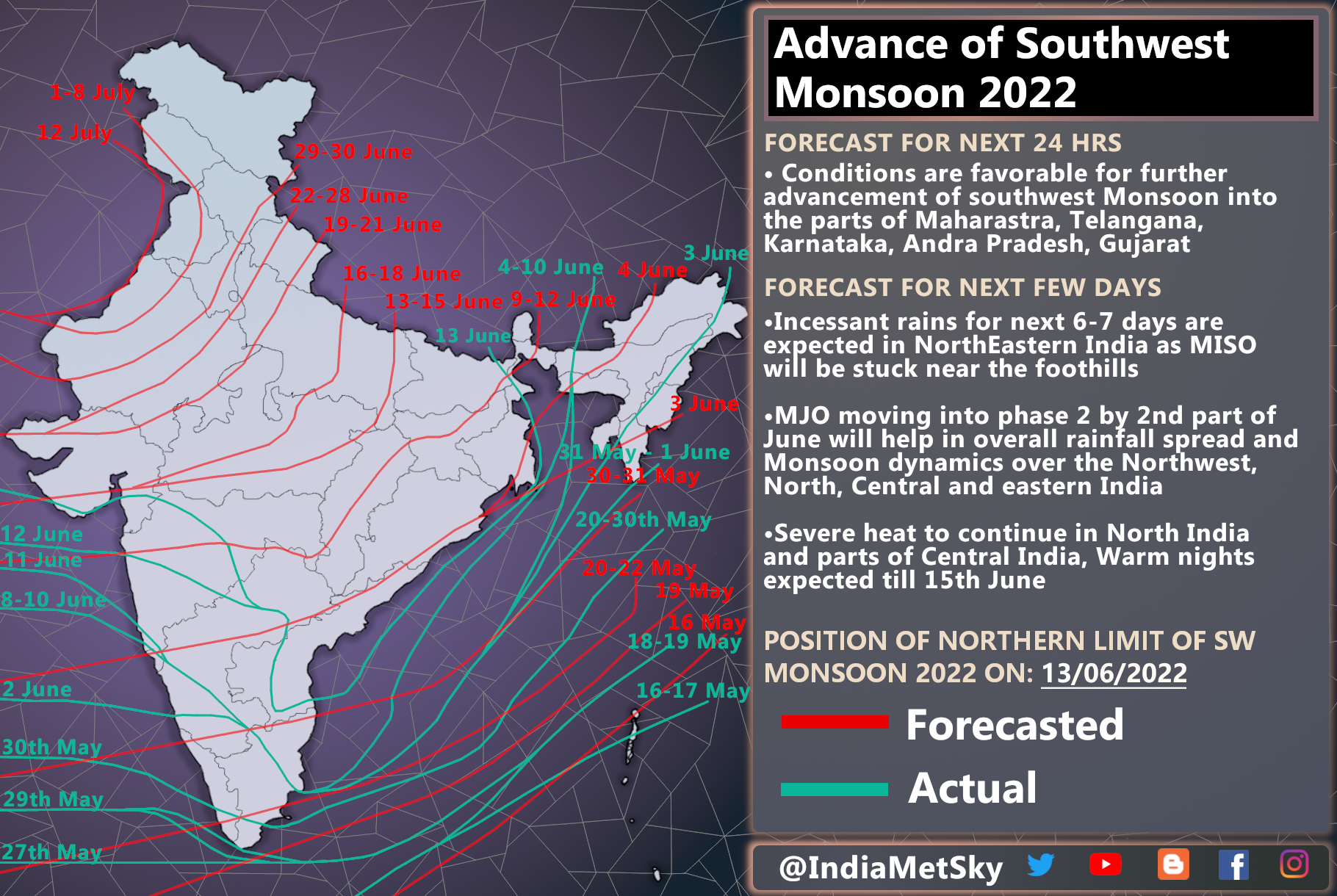
• The 4 months long season indicated its arrival over Indian mainland on 30th May as the monsoon current sets over Kerala and satisfies the onset criteria but onset was weaker.
•As per our analysis, we are expecting a near normal monsoon season with pan India performance to be between 96% to 104% of Long Period Average (LPA). Considering LPA of 880mm for India, hence we are expecting the rainfall to be anywhere between 845mm to 915mm with a error margin of +/-4%
•La-nina conditions continue but with a weakening trend during first 2 months. atleast for 50% journey of this 4 month long season. This weakening trend to make Maiden Julian Oscillation to remain active over West Pacific and Maritime Continent, causing sea surface temperatures to drop over West Indian Ocean (WIO) & Arabian sea and increased SST over East Indian Ocean. Hence reversal of walker circulation over North Indian Ocean (NIO) and causing suppression in WIO & AS.
•MJO is likely to remain in phases 3-5, if it becomes stationary in Indian Ocean, then it will cause monsoon to perform below normal
•Negative Indian Ocean Dipole (IOD), This will have a poor impact on monsoon performance. IOD is the main driver for the formation and advancement of monsoon. Until now IOD was negative and this is one of the reason for sluggish performance of SWM in past 14 days of June and expecting moderate to strong negative IOD. Also last year we had similar IOD anomalies
•Conductive Jet Stream patterns for free fluid flow of monsoon currents over majority of India but sometimes above mentioned drivers have tendency to hamper the flow of these currents
•Considering all the given synoptic conditions, we are expecting a near normal monsoon which will pick up in late June into early July.
Here's our performance distribution forecast

DETAILED OUTLOOK
JUNE
•First 14 days of June ends with large deficit across majority of India
•Heatwave conditions prevailed in the north India and parts of central India
•Slightly below normal rains are expected in southern India and parts of North, East and central India. Some places in North India to witness slightly below normal pre-monsoon rains.
•Monsoon to pick up by first half of June
•Parts of South India to receive below normal rainfall
•North, NorthWest and parts of central India to receive pre-monsoon rains from late 15th June which will pave the way for further advancement of monsoon
•SW Monsoon made onset over Mumbai and other parts of western coast of India between 10-13 June and now we expect isolated rains for few days then another spell of moderate to heavy rains 18-21 June but not very heavy
•A upper level UAC, LPA is expected to form over eastern India by 22nd June which will help in further progress of monsoon and rainfall acts
•Somali Jet is picking up and it could trigger the eastern branch of monsoon which along with the help of -IOD and atmospheric wave will produce some good intensity rains across eastern India including Odisha, West Bengal and neighbouring places during 16-25th June
OVERALL OUTLOOK
•Monsoon performance will be jittery for atleast 40-55% of the season but late July, August and September looks good in terms of spread and intensity
•NorthEast India to get torrential rainfall but some areas could miss out the action
•North, Central and Northwest India to get good rains just like the last year. some areas could get above average rainfall
•Poor performance for the parts of southwestern India
•We are expecting 4-8 Low Pressures to form during this 4 month long period. only 1 Low is expected to form in 2nd half of June
Hereby, with all the parameters being satisfied over Kerala. We welcome this 4 month long season of SW Monsoon over India


Comments
Post a Comment